A lot of our chapter members and perhaps others who have subscribed to this newsletters have written me for information on where I get my maps, fishing maps, and how they might be able to get this information on their computers.
If you have a PC and not a MAC (Apple propriatary system) then I've got some great info for you.
How to:
Create a shortcut to CT Deep on your desktop:
On your desktop, find a blank area and click the left mouse button.
Select NEW from the dropdown, then SHORTCUT from the selection bar.
This is what you get:

Fill the following info on the line then click next at the bottom of the page.
After you click next, you’ll get this screen – fill in the line with whatever you want to name the shortcut. It will be displayed on your desktop under the shortcut icon.

Now, Click Finish.
Now, you’re ready to try your shortcut. Double-click on the icon. You’ll get the homepage at
www.ct.gov/deep

Click on fishing. Your next screen will look something like this:

Once you select something, the cookies on the website will mark it in red for you, to make it easier to use it again. Over on the side in the “Featured Links” section, I regularly visit the Angler’s Guide (see if anything’s changed since you last fished a particular area) and Trout Stocking Maps, which I used all the time. In the center section, I’ve visited ‘Weekly Fishing Reports” which now, you can subscribe to in email, and “Current Stocking Reports) which gives detailed information.
The majority of the overheads I print come from Google Earth Pro. Once I put in what info I want, I'll capture and save it into an image file then insert it into the newsletter.
|
|
|
|
|
Welcome Back Meeting
Annual Picnic & Outing
|
|
|
Don't forget! Our next meeting is on September 5th, 7:30 pm at the Torrington Elks Lodge.
Our Annual Outing/Picnic is on September 9th, at Housatonic Meadows State Park, in Cornwall Bridge, CT.
If you have a PC and not a MAC and you'd like help on downloading and installing Adobe Reader so that you can view and print maps and other documents of interest from the DEEP website and other websites, send me an
email to me at the email address up on top (nwct009tu@gmail.com) and I'll send you instructions on how to do it. It's really fast and easy!
|
|
|
|
|
A lot of people forget that there are actually two TMA's on the upper Housatonic River. The well known TMA begins at the concrete bridge on US-7 just adjacent to Lime Rock Road(CT-112) in Falls Village and ends at the Concrete Bridge at the intersection of US-7 and CT-4, in Cornwall Bridge, just south of Housatonic Meadows State Park. The Bulls Bridge TMA begins at Bulls Bridge Road which intersects US-7, about 10 miles south of Cornwall Bridge, and about two miles south of the intersection of CT-341 and US-7 in the village of Kent, CT. This second TMA is a tailwater fishery, and ends just north of Gaylordsville, CT/Route 55. This area also has about two miles of the Tenmile River, and the Appalachian Trail is just above the west bank of the river for at least three miles.
There's a lot of different kinds of water in this TMA. There's lots of riffles, containing rocks nearer to the surface, with lots of pocket water, there's plenty of deep runs, and there's lots of pools. There's also a lot of different kind of rocks in the area,


and the slower sections of the river hold lots of Pike and Smallmouth Bass and lots of other wildlife.
There are basically four ways to get to the Bullls Bridge TMA.
1. From Kent, take the bridge on 341 over the Housatonic to the Kent School

and turn left on Schaghticoke Rd. The TMA begins about 3/4 of a mile south of the Indian Reservation.
There's an excellent backwater area of the Housatonic before you pass the reservation, and there's a great area for pike and smallmouth between the dams on the left side of the road before you reach Bulls Bridge Rd.

2. From Bulls Bridge Road. From US-7, turn onto Bulls Bridge Rd, drive through the bridge and park. The TMA is downriver of you. (Towards Gaylordsville).
3. From Bulls Bridge Road. Take Bulls Bridge road to Dogtail Corners Rd. At the intersection of E. Mountain Road and Lake Ellis Road, turn left and take the first left onto an unpaved road (directly under the powerlines)


The vertical line you see in the maps is the NY State Border. You'll pass back into CT on the unpaveed road you see in the lower map. The parking area at the end is just northwest of the confluence of the Tenmile River/Housatonic River. This is an excellent area to fish year round.
4. On Route 7, there are several pulloffs including a large parking lot norh of the Bulls Bridge Hydro Station,

the Hydro Station itself has a large parking lot,
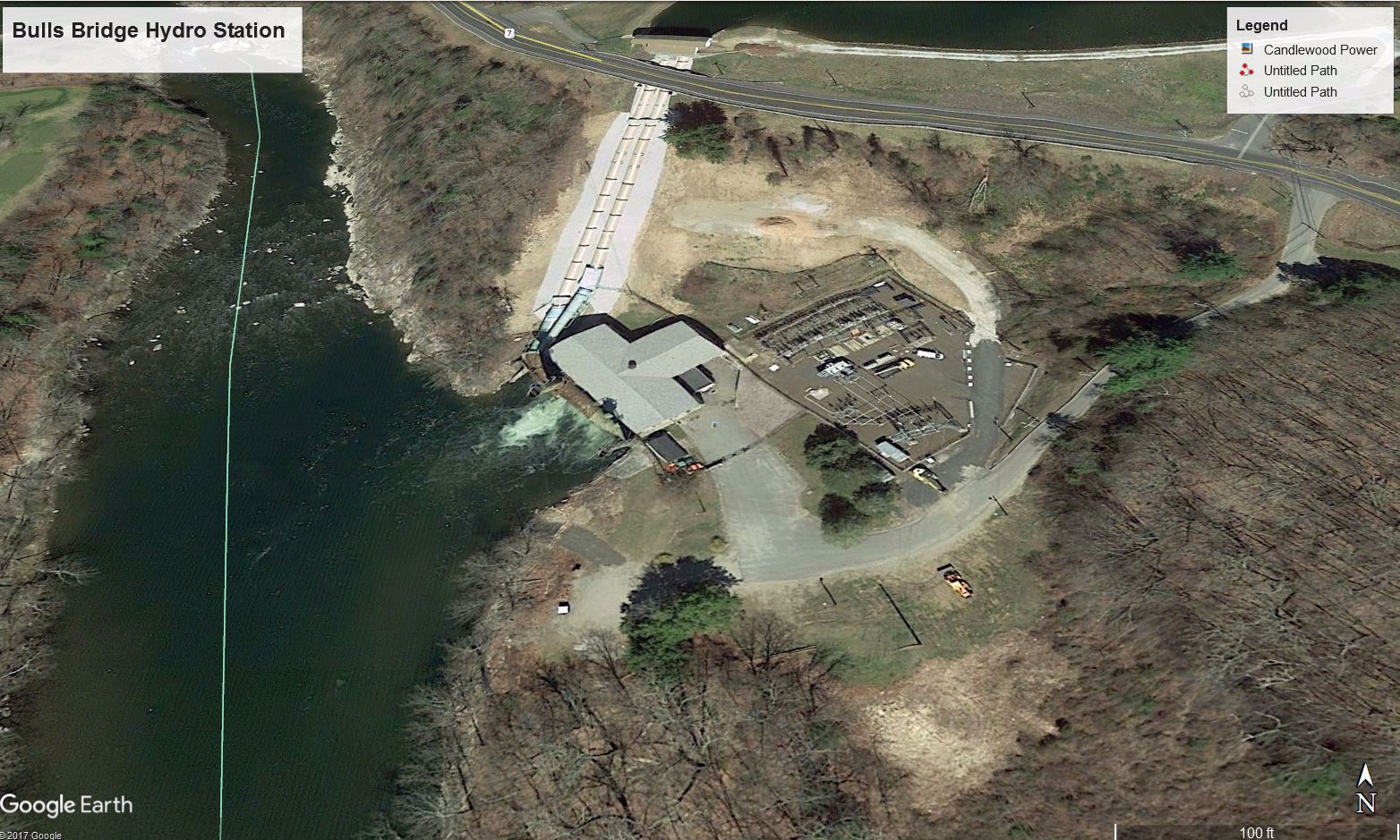
there are a couple of pulloffs on Route 7 at the southernmost end of the TMA.

If you park at the BB Hydro Plant, or in the parking lot above it, Like I do, have a look at this great bend on the river. Lots of action here, remember DEEP stocks about 9000 fish in this area every year, and this water stays pretty cold due to the hydro plant and the dams above.
 Thiis last photo shows the beginning of the TMA on the left of US-7 and the beginning of the two mile long Canal, dug in 1902 to support the Hydro Station. This canal was dug by thousands of immigrants jjust after the turn of the century. Thiis last photo shows the beginning of the TMA on the left of US-7 and the beginning of the two mile long Canal, dug in 1902 to support the Hydro Station. This canal was dug by thousands of immigrants jjust after the turn of the century.
Here's a website that can tell you all about the
Hydro Dam at Bulls Bridge. |
|
|
|
|